
Thank you for supporting this site ❤️
Make a donation
Make a donation
Viðareiði topographic map
Click on the map to display elevation.
Thank you for supporting this site ❤️
Make a donation
Make a donation
About this map
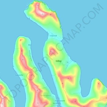
Name: Viðareiði topographic map, elevation, terrain.
Location: Viðareiði, Norðoyar region, 750, Faroe Islands (62.29104 -6.59546 62.39430 -6.41538)
Average elevation: 127 m
Minimum elevation: -11 m
Maximum elevation: 843 m
Thank you for supporting this site ❤️
Make a donation
Make a donation
Other topographic maps
Click on a map to view its topography, its elevation and its terrain.