
Thank you for supporting this site ❤️
Make a donation
Make a donation
Sangerhausen topographic map
Click on the map to display elevation.
Thank you for supporting this site ❤️
Make a donation
Make a donation
About this map
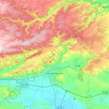
Name: Sangerhausen topographic map, elevation, terrain.
Location: Sangerhausen, Mansfeld-Südharz, Saxony-Anhalt, Germany (51.41435 11.07100 51.59866 11.38706)
Average elevation: 262 m
Minimum elevation: 122 m
Maximum elevation: 457 m
Thank you for supporting this site ❤️
Make a donation
Make a donation
Other topographic maps
Click on a map to view its topography, its elevation and its terrain.