
Thank you for supporting this site ❤️
Make a donation
Make a donation
Cerro del Cuatro topographic map
Click on the map to display elevation.
Thank you for supporting this site ❤️
Make a donation
Make a donation
About this map
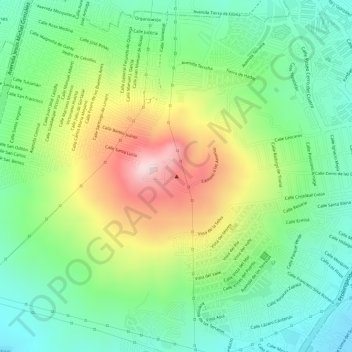
Name: Cerro del Cuatro topographic map, elevation, terrain.
Average elevation: 1,684 m
Minimum elevation: 1,563 m
Maximum elevation: 1,871 m
Thank you for supporting this site ❤️
Make a donation
Make a donation
Other topographic maps
Click on a map to view its topography, its elevation and its terrain.
Parque Colinas de Chapultepec
Mexico > Jalisco > San Pedro Tlaquepaque > Tlaquepaque
Average elevation: 1,596 m