
Make a donation
Palenque topographic map
Click on the map to display elevation.
Make a donation
About this map
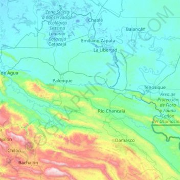
Name: Palenque topographic map, elevation, terrain.
Location: Palenque, Chiapas, 29960, Mexico (17.06701 -92.35019 17.83947 -91.26041)
Average elevation: 314 m
Minimum elevation: -7 m
Maximum elevation: 2,102 m
Make a donation
Other topographic maps
Click on a map to view its topography, its elevation and its terrain.
San Cristóbal
Mexico > Chiapas > San Cristóbal de las Casas
The city and municipality are located in a region called the Chiapas Highlands or Central Highlands. Two thirds of the municipality is made up of mountainous terrain with the rest valley floor. The city proper is located at 2,200 meters above sea level in a small valley surrounded by hills. The most important…
Average elevation: 2,038 m
Make a donation
Tapachula
The cuisine of the municipality varies greatly as the topography extends from the ocean into the mountains. Main annual events include Chinese New Year, San Benito, the Feria Tapachula, San Agustín, Jesús de la Buena Esperanza and San Miguel.
Average elevation: 202 m
Make a donation
San Cristóbal
Mexico > Chiapas > San Cristóbal de las Casas
The city and municipality are located in a region called the Chiapas Highlands or Central Highlands. Two thirds of the municipality is made up of mountainous terrain with the rest valley floor. The city proper is located at 2,200 meters above sea level in a small valley surrounded by hills. The most important…
Average elevation: 2,038 m
Make a donation
Tuxtla Gutiérrez
Mexico > Chiapas > Tuxtla Gutiérrez
On the edge of the city is the El Zapotal Ecological Reserve, best known as the home of the Zoológico Miguel Alvarez del Toro Zoo, often referred to as the ZooMAT. The zoo covers 100 hectares and was founded by Miguel Alvarez del Toro in 1942. He was also the director for over fifty years. ZooMAT is…
Average elevation: 817 m
Make a donation
Reserva de la Biósfera Selva El Ocote
Mexico > Chiapas > Ocozocoautla de Espinosa
Average elevation: 609 m
Make a donation
Make a donation