
Make a donation
Niš topographic map
Click on the map to display elevation.
Make a donation
About this map
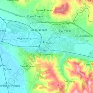
Name: Niš topographic map, elevation, terrain.
Location: Niš, Nisava Administrative District, Central Serbia, Serbia (43.28340 21.82634 43.35033 21.96023)
Average elevation: 249 m
Minimum elevation: 182 m
Maximum elevation: 443 m
Make a donation
Other topographic maps
Click on a map to view its topography, its elevation and its terrain.
Бања Топило
Serbia > Central Serbia > Nisava Administrative District > Градска општина Црвени Крст
Average elevation: 391 m
Deligrad
Serbia > Central Serbia > Nisava Administrative District > Aleksinac Municipality
Average elevation: 179 m
Vrelo
Serbia > Central Serbia > Nisava Administrative District > Градска општина Пантелеј
Average elevation: 518 m
Раван
Serbia > Central Serbia > Nisava Administrative District > Aleksinac Municipality
Average elevation: 979 m
Make a donation