
Thank you for supporting this site ❤️
Make a donation
Make a donation
Semmering topographic map
Click on the map to display elevation.
Thank you for supporting this site ❤️
Make a donation
Make a donation
Semmering
Semmering is located on the border of Lower Austria and Styria at an elevation of 1,000 m (3,280 ft) above sea level and surrounded with forest. Semmering city is located in Neunkirchen, about 100 km (60 mi) from Vienna.
Thank you for supporting this site ❤️
Make a donation
Make a donation
About this map
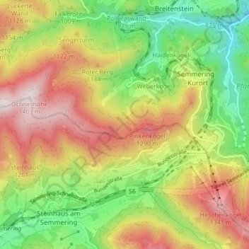
Name: Semmering topographic map, elevation, terrain.
Location: Semmering, Bezirk Neunkirchen, Lower Austria, 2680, Austria (47.61810 15.78132 47.65734 15.85002)
Average elevation: 1,001 m
Minimum elevation: 653 m
Maximum elevation: 1,401 m
Thank you for supporting this site ❤️
Make a donation
Make a donation