
Thank you for supporting this site ❤️
Make a donation
Make a donation
Offenbach am Main topographic map
Click on the map to display elevation.
Thank you for supporting this site ❤️
Make a donation
Make a donation
About this map
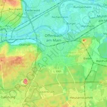
Name: Offenbach am Main topographic map, elevation, terrain.
Location: Offenbach am Main, Hesse, Germany (50.04682 8.72245 50.13740 8.84273)
Average elevation: 118 m
Minimum elevation: 95 m
Maximum elevation: 171 m
Thank you for supporting this site ❤️
Make a donation
Make a donation
Other topographic maps
Click on a map to view its topography, its elevation and its terrain.