
Thank you for supporting this site ❤️
Make a donation
Make a donation
Halmahera topographic map
Click on the map to display elevation.
Thank you for supporting this site ❤️
Make a donation
Make a donation
About this map
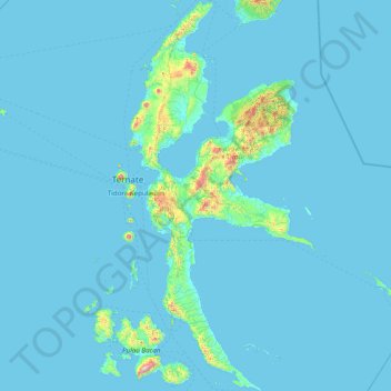
Name: Halmahera topographic map, elevation, terrain.
Location: Halmahera, North Maluku, Maluku, Indonesia (-0.91420 127.39692 2.22151 128.90329)
Average elevation: 46 m
Minimum elevation: 0 m
Maximum elevation: 1,995 m
Thank you for supporting this site ❤️
Make a donation
Make a donation
Other topographic maps
Click on a map to view its topography, its elevation and its terrain.
Thank you for supporting this site ❤️
Make a donation
Make a donation
Mount Gamkonora
Indonesia > North Maluku > Halmahera Barat > Tabobol
Mount Gamkonora is a stratovolcano on Halmahera island, Indonesia. With an elevation of 1,560 metres (5,118 ft), it is the highest peak on the island. It has produced an elongated series of craters along the north–south rift.
Average elevation: 1,113 m
Thank you for supporting this site ❤️
Make a donation
Make a donation
Thank you for supporting this site ❤️
Make a donation
Make a donation
Thank you for supporting this site ❤️
Make a donation
Make a donation