
Make a donation
Digne-les-Bains topographic map
Click on the map to display elevation.
Make a donation
Digne-les-Bains
Digne-les-Bains is the capital of the Department of Alpes de Haute-Provence. Placed in the geographical centre of the Department, the commune is home to 17,400 inhabitants, making it one of the smaller prefectures of France by its population. The town centre is at 608 metres (1,995 ft) altitude.
Make a donation
About this map
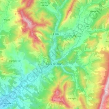
Name: Digne-les-Bains topographic map, elevation, terrain.
Average elevation: 869 m
Minimum elevation: 501 m
Maximum elevation: 1,669 m
Make a donation
Other topographic maps
Click on a map to view its topography, its elevation and its terrain.
Revest
France > Provence-Alpes-Côte d'Azur > Alpes-de-Haute-Provence > Malijai
Average elevation: 524 m
Molanès
France > Provence-Alpes-Côte d'Azur > Alpes-de-Haute-Provence > Uvernet-Fours
Average elevation: 1,566 m
Le Caravon
France > Provence-Alpes-Côte d'Azur > Alpes-de-Haute-Provence > Oppedette
Average elevation: 553 m
Chavailles
France > Provence-Alpes-Côte d'Azur > Alpes-de-Haute-Provence > Prads-Haute-Bléone
Average elevation: 1,491 m
Make a donation
La Croix
France > Provence-Alpes-Côte d'Azur > Alpes-de-Haute-Provence > Jausiers
Average elevation: 2,128 m
Mont d'Or
France > Provence-Alpes-Côte d'Azur > Alpes-de-Haute-Provence > Manosque
Average elevation: 394 m
Saint-Michel
France > Provence-Alpes-Côte d'Azur > Alpes-de-Haute-Provence > Moustiers-Sainte-Marie
Average elevation: 731 m
La Foux d'Allos
France > Provence-Alpes-Côte d'Azur > Alpes-de-Haute-Provence > Allos
Average elevation: 2,094 m
Make a donation
Colmars
France > Provence-Alpes-Côte d'Azur > Alpes-de-Haute-Provence > Colmars > Colmars
Average elevation: 1,565 m
Barcelonnette
France > Provence-Alpes-Côte d'Azur > Alpes-de-Haute-Provence > Barcelonnette > Barcelonnette
Barcelonnette is situated in the wide and fertile Ubaye Valley, of which it is the largest town. It lies at an elevation of 1132 m (3717 ft) on the right bank of the Ubaye River, and is surrounded by mountains which reach peaks of over 3000 m; the tallest of these is the Needle of Chambeyron at 3412 m.…
Average elevation: 1,494 m
Aurafrède
France > Provence-Alpes-Côte d'Azur > Alpes-de-Haute-Provence > Gréoux-les-Bains
Average elevation: 389 m
Brame-Faim
France > Provence-Alpes-Côte d'Azur > Alpes-de-Haute-Provence > Mirabeau
Average elevation: 624 m
Make a donation
Pont de la Serre
France > Provence-Alpes-Côte d'Azur > Alpes-de-Haute-Provence > Colmars
Average elevation: 1,990 m
La Colle Saint-Michel
France > Provence-Alpes-Côte d'Azur > Alpes-de-Haute-Provence > Thorame-Haute
Average elevation: 1,370 m