
Make a donation
Nouvelle-Aquitaine topographic map
Click on the map to display elevation.
Make a donation
Nouvelle-Aquitaine
The region Nouvelle-Aquitaine essentially has a more or less altered oceanic climate. We distinguish the Aquitaine oceanic climate, which concerns most of the territory (Charentes to Landes), the Paris oceanic climate (Poitou), Limousin oceanic climate, tinged with semi-continental influences (Limousin) and basque microclimate, wetter (western half of the Pyrénées-Atlantiques and southern Landes). The Pyrenees has a specific climate that varies with altitude: the Pyrenean climate, which is a variation of mountain climate.
Make a donation
About this map
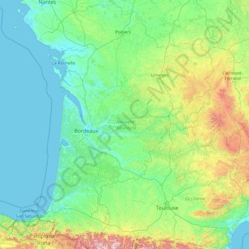
Name: Nouvelle-Aquitaine topographic map, elevation, terrain.
Location: Nouvelle-Aquitaine, Metropolitan France, France (42.77754 -1.79102 47.17592 2.61150)
Average elevation: 258 m
Minimum elevation: -2 m
Maximum elevation: 3,093 m
Make a donation
Other topographic maps
Click on a map to view its topography, its elevation and its terrain.
Val Thorens
France > Auvergne-Rhône-Alpes > Savoy
Val Thorens ([val tɔʁɑ̃]) is a ski town in the Tarentaise Valley in the French Alps at an altitude of 2,300 m (7,500 ft). It is located in the commune of Saint-Martin-de-Belleville in the Savoie department. The resort forms part of the Les Trois Vallées ski area which, with over 600 km of slopes, is one…
Average elevation: 2,516 m
Laudibertie
France > Nouvelle-Aquitaine > Dordogne > Saint-Privat-en-Périgord > Festalemps
Average elevation: 93 m
Make a donation
Make a donation
Lavillemichel
France > Nouvelle-Aquitaine > Haute-Vienne > Bessines-sur-Gartempe
Average elevation: 349 m
Make a donation
Beauregard
France > Bourgogne – Franche-Comté > Nièvre > Saint-Amand-en-Puisaye
Average elevation: 220 m
Make a donation
Make a donation
La Fageole
France > Nouvelle-Aquitaine > Dordogne > Saint-Félix-de-Reillac-et-Mortemart
Average elevation: 213 m
Les Gardes
France > Auvergne-Rhône-Alpes > Cantal > Saint-Jacques-des-Blats
Average elevation: 1,266 m
Make a donation
Make a donation
Make a donation
La Madone de Fenestre
France > Provence-Alpes-Côte d'Azur > Saint-Martin-Vésubie > La Madone de Fenestre
Average elevation: 2,202 m
Make a donation
Paris
Paris in its early history had only the rivers Seine and Bièvre for water. From 1809, the Canal de l'Ourcq provided Paris with water from less-polluted rivers to the north-east of the capital. From 1857, the civil engineer Eugène Belgrand, under Napoleon III, oversaw the construction of a series of new…
Average elevation: 75 m
Make a donation