
Thank you for supporting this site ❤️
Make a donation
Make a donation
Demre topographic map
Click on the map to display elevation.
Thank you for supporting this site ❤️
Make a donation
Make a donation
About this map
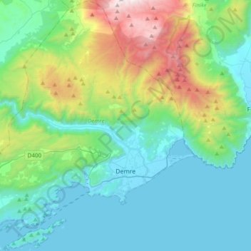
Name: Demre topographic map, elevation, terrain.
Location: Demre, Antalya, Mediterranean Region, Turkey (36.16681 29.78889 36.41041 30.07169)
Average elevation: 495 m
Minimum elevation: -4 m
Maximum elevation: 2,246 m
Thank you for supporting this site ❤️
Make a donation
Make a donation
Other topographic maps
Click on a map to view its topography, its elevation and its terrain.
Mount Ararat
Mount Ararat (/ˈærəræt/, ARR-ə-rat; Armenian: Արարատ, romanized: Ararat), also known as Mount Ağrı (Turkish: Ağrı Dağı) or Masis (Armenian: Մասիս), is a snow-capped and dormant compound volcano in eastern Turkey. It consists of two major volcanic cones: Greater Ararat and Little Ararat.…
Average elevation: 4,582 m
Thank you for supporting this site ❤️
Make a donation
Make a donation
Thank you for supporting this site ❤️
Make a donation
Make a donation