
Make a donation
Salar de Atacama topographic map
Click on the map to display elevation.
Make a donation
Salar de Atacama
The salt flat encompasses 3,000 km2 (1,200 sq mi), is about 100 km (62 mi) long and 80 km (50 mi) wide, which makes it the third largest in the world, after Salar de Uyuni in Bolivia (10,582 km2 (4,086 sq mi)). and Salinas Grandes in Argentina (6,000 km2 (2,300 sq mi)). Its average elevation is about 2,300 m above sea level. The topography of the core portion of the salar exhibits a high level of roughness, the result of evaporation and ephemeral surface water, unlike the most other salt flats, as for example the Salar de Uyuni, which is periodically covered with shallow water.
Make a donation
About this map
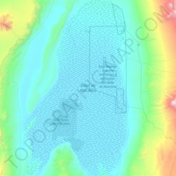
Name: Salar de Atacama topographic map, elevation, terrain.
Location: Salar de Atacama, Antofagasta Region, Chile (-23.78629 -68.57340 -22.99316 -68.06436)
Average elevation: 2,632 m
Minimum elevation: 2,298 m
Maximum elevation: 5,269 m
Make a donation
Other topographic maps
Click on a map to view its topography, its elevation and its terrain.
Norte Grande
Chile > Antofagasta Region > Provincia de Antofagasta > Sierra Gorda
The desert region is an elevated arid plateau descending gradually from the Andes towards the coast, where it breaks down abruptly from elevations of 800 to 1500 ft. From the sea this plateau escarpment has the appearance of a range of flat topped hills closely following the coast line. This topography…
Average elevation: 2,112 m