
Thank you for supporting this site ❤️
Make a donation
Make a donation
Doğubayazıt topographic map
Click on the map to display elevation.
Thank you for supporting this site ❤️
Make a donation
Make a donation
Doğubayazıt
Doğubayazıt (Kurdish: Bazîd) is a district of Ağrı Province of Turkey, and it is the easternmost district of Turkey, lying near the border with Iran. Its elevation is 1625m and its area is 2,383 km². Doğubayazıt's population in 2010 was 115,354 (up from 73,794 in 1980) of which 69,447 live in the town of Doğubayazıt, the remainder in the surrounding countryside.
Thank you for supporting this site ❤️
Make a donation
Make a donation
About this map
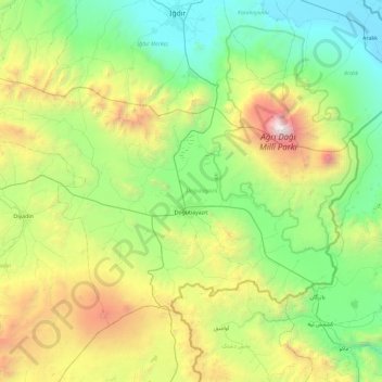
Name: Doğubayazıt topographic map, elevation, terrain.
Location: Doğubayazıt, Ağrı, Eastern Anatolia Region, 04400, Turkey (39.33360 43.55737 39.83868 44.48772)
Average elevation: 1,914 m
Minimum elevation: 813 m
Maximum elevation: 5,067 m
Thank you for supporting this site ❤️
Make a donation
Make a donation
Other topographic maps
Click on a map to view its topography, its elevation and its terrain.