
Make a donation
Hunsrück topographic map
Click on the map to display elevation.
Make a donation
About this map
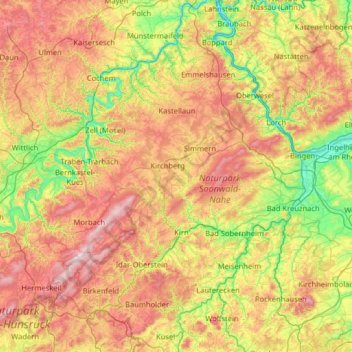
Name: Hunsrück topographic map, elevation, terrain.
Location: Hunsrück, Rhineland-Palatinate, Germany (49.51488 6.59316 50.31777 7.87444)
Average elevation: 352 m
Minimum elevation: 66 m
Maximum elevation: 817 m
Make a donation
Other topographic maps
Click on a map to view its topography, its elevation and its terrain.
Waldfischbach
Germany > Rhineland-Palatinate > Südwestpfalz > Waldfischbach-Burgalben
Average elevation: 326 m
Make a donation
Betzdorf
Germany > Rhineland-Palatinate > Landkreis Altenkirchen (Westerwald)
Average elevation: 277 m
Make a donation
Schönenberg-Kübelberg
Germany > Rhineland-Palatinate > Landkreis Kusel
The municipality of Schönenberg-Kübelberg lies in the Western Palatinate near the boundary with the Saarland some 15 km south of Kusel, and 10 km northeast of Homburg. The two Ortsteile lie at the edge of the Landstuhler Bruch (a hollow). Kübelberg on the long mountain ridge south of the Klingbach runs…
Average elevation: 268 m
Rhine Gorge
Germany > Rhineland-Palatinate > Rhein-Hunsrück-Kreis > Sankt Goar > Biebernheim
Average elevation: 177 m
Make a donation
Rhine Gorge
Germany > Rhineland-Palatinate > Rhein-Hunsrück-Kreis > Sankt Goar > Biebernheim
Average elevation: 177 m
Nürburg
Germany > Rhineland-Palatinate > Landkreis Ahrweiler
Nürburg has a semi-continental climate with both oceanic and continental tendencies. It does however land in the former category (Köppen Cfb). With regards to the racetrack, due to the Nordschleife's varied terrain and elevation, weather may be completely different on either end of the track. The elevation…
Average elevation: 560 m
Make a donation
Carlsberg
Germany > Rhineland-Palatinate > Landkreis Bad Dürkheim
The municipality lies at the north edge of the Palatinate Forest between the Haardt range in the south and the Autobahn A 6 in the north in the Leiningerland at an elevation of 285 m above sea level. Carlsberg belongs to the Verbandsgemeinde of Leiningerland, whose seat is in Grünstadt.
Average elevation: 327 m
Laudert
Germany > Rhineland-Palatinate > Rhein-Hunsrück-Kreis
North of Laudert, cleft here and there by the Autobahn or high-voltage transmission lines, is an otherwise continuous expanse of higher-elevation forest growing above mainly greywacke bedrock. In these woods, roughly a kilometre away from the village, in a swampy area that once afforded protection against…
Average elevation: 490 m
Falkenstein
Germany > Rhineland-Palatinate > Donnersbergkreis
The linear settlement is located along an old pass road that reaches its highest elevation at 464 m (1522 ft). The village's main street is one of the steepest public roads in Germany with a 25% gradient. Along the road to Winnweiler the Falkensteiner Tal (Falkenstein Valley), known for its rock formations is…
Average elevation: 412 m
Make a donation
Birgel
Germany > Rhineland-Palatinate > Landkreis Vulkaneifel
The municipality belongs to the Kalkeifel (“Limestone Eifel”) and lies on the southern edge of the Dollendorf Limestone Basin (Dollendorfer Kalkmulde). The elevation ranges from about 400 m above sea level on the Kyll at Crumpsmühle to about 526 m above sea level at the Hirzberg (mountain).
Average elevation: 450 m
Wingendorf
Germany > Rhineland-Palatinate > Landkreis Altenkirchen (Westerwald)
Average elevation: 285 m
Wackernheim
Germany > Rhineland-Palatinate > Landkreis Mainz-Bingen > Ingelheim am Rhein
Average elevation: 220 m
Make a donation
Ramstein-Miesenbach
Germany > Rhineland-Palatinate > Landkreis Kaiserslautern
Average elevation: 266 m
Make a donation
Ahr
Germany > Rhineland-Palatinate
Ahr (German pronunciation: [ˈaːɐ̯]) is a river in Germany, a left tributary of the Rhine. Its source is at an elevation of approximately 470 metres (1,540 ft) above sea level in Blankenheim in the Eifel, in the cellar of a timber-frame house near the castle of Blankenheim. After 18 kilometres (11 mi) it…
Average elevation: 367 m
Westerwald
Germany > Rhineland-Palatinate
The Westerwald (German pronunciation: [ˈvɛstɐvalt] ; literally 'Western forest') is a low mountain range on the right bank of the river Rhine in the German federal states of Rhineland-Palatinate, Hesse and North Rhine-Westphalia. It is a part of the Rhenish Massif (Rheinisches Schiefergebirge or Rhenish…
Average elevation: 290 m
Erbel
Germany > Rhineland-Palatinate > Landkreis Altenkirchen (Westerwald) > Fluterschen
Average elevation: 281 m
Make a donation
Der Auborn
Germany > Rhineland-Palatinate > Landkreis Südliche Weinstraße > Schweighofen
Average elevation: 155 m
Make a donation
Bernkastel-Kues
Germany > Rhineland-Palatinate > Landkreis Bernkastel-Wittlich
Bernkastel-Kues lies in the Mosel valley, roughly 50 km (31 mi) from Trier. The greatest elevation is the Olymp (415 m above sea level), and the lowest point (107 m above sea level) lies on the Mosel's banks. The municipal area totals 23 657 101 m2, of which 7 815 899 m2 is used for agriculture, thereby making…
Average elevation: 269 m
Make a donation
Make a donation
Make a donation
Make a donation
Eifel
Germany > Rhineland-Palatinate > Landkreis Ahrweiler > Adenau
The Eifel is in the Atlantic climate zone with its relatively high precipitation; winters that are moderately cold and long with periods of snow; and summers that are often humid and cool. The prevailing wind is west/southwest. A relatively dry and milder climate prevails in the wind and rain shadow of the…
Average elevation: 585 m
Make a donation
Nürburg
Germany > Rhineland-Palatinate > Landkreis Ahrweiler
Nürburg has a semi-continental climate with both oceanic and continental tendencies. It does however land in the former category (Köppen Cfb). With regards to the racetrack, due to the Nordschleife's varied terrain and elevation, weather may be completely different on either end of the track. The elevation…
Average elevation: 560 m
Make a donation
Dockweiler
Germany > Rhineland-Palatinate > Landkreis Vulkaneifel
The municipality lies on the watershed between the Ahr and the Moselle in the heart of the Vulkaneifel, a part of the Eifel known for its volcanic history, geographical and geological features, and even ongoing activity today, including gases that sometimes well up from the earth. Dockweiler lies in the north…
Average elevation: 558 m
Make a donation
Make a donation
Katz Castle
Germany > Rhineland-Palatinate > Rhein-Lahn-Kreis > Sankt Goarshausen > Heide
Average elevation: 178 m
Make a donation
Make a donation
Gipperath
Germany > Rhineland-Palatinate > Landkreis Bernkastel-Wittlich
The municipality lies in the Vulkaneifel. The municipal area is 42% wooded. The nearest forest is called Geisbüch. Gipperath belongs to the Verbandsgemeinde Wittlich-Land. Its elevation is 370 m above sea level.
Average elevation: 353 m
Make a donation
Make a donation
Cochem
Germany > Rhineland-Palatinate > Landkreis Cochem-Zell
Cochem lies at an elevation of some 83 m above sea level and the municipal area measures 21.2 km2. The town centre with the outlying centre of Sehl upstream lies on the Moselle's left bank, while the constituent centre of Cond lies on its right. A further constituent centre, Brauheck, with its commercial area,…
Average elevation: 286 m
53578
Germany > Rhineland-Palatinate > Landkreis Neuwied > Windhagen > Johannisberg
Average elevation: 261 m
Reichenbach-Steegen
Germany > Rhineland-Palatinate > Landkreis Kaiserslautern
Average elevation: 336 m
Make a donation
Make a donation
Weyher in der Pfalz
Germany > Rhineland-Palatinate > Landkreis Südliche Weinstraße
Average elevation: 316 m
Make a donation
Friedewald
Germany > Rhineland-Palatinate > Landkreis Altenkirchen (Westerwald)
Average elevation: 484 m
Make a donation