
Thank you for supporting this site ❤️
Make a donation
Make a donation
Court-Saint-Etienne topographic map
Click on the map to display elevation.
Thank you for supporting this site ❤️
Make a donation
Make a donation
About this map
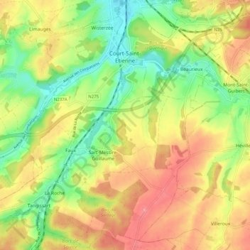
Name: Court-Saint-Etienne topographic map, elevation, terrain.
Average elevation: 113 m
Minimum elevation: 57 m
Maximum elevation: 173 m
Thank you for supporting this site ❤️
Make a donation
Make a donation
Other topographic maps
Click on a map to view its topography, its elevation and its terrain.
Quatre-Bras de Baisy-Thy
Belgium > Walloon Brabant > Nivelles > Genappe > Baisy-Thy > Quatre-Bras de Baisy-Thy
Average elevation: 146 m
Thank you for supporting this site ❤️
Make a donation
Make a donation