
Make a donation
Umnak Island topographic map
Click on the map to display elevation.
Make a donation
Umnak Island
Umnak, the third largest of the Aleutian Islands after Unimak and Unalaska, lies in the Fox Islands of the Aleutian Islands of the Bering Sea, to the southwest of the larger island of Unalaska. It is approximately 70–72 miles (113–116 km) in length (117 kilometres (73 mi)) and 16 miles (26 km) wide on average. The island was separated in the last glacial period and now lies about 300 kilometres (190 mi) from North American shores. It is an active volcanic island, with a land area of 1,793.2 km2 (692.4 sq mi) and with a coastline extending over 330.2 kilometres (205.2 mi). The elevation of the island is 2,132 metres (6,995 ft). The island is very mountainous with a low level of vegetation. The island does not have a harbor, although a sizeable bay is located in the western part of the island and contains the Adugak Island. The southern point of the island is known as Cape Sagak.
Make a donation
About this map
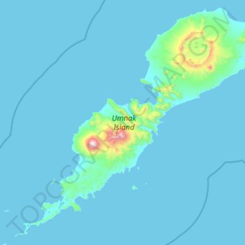
Name: Umnak Island topographic map, elevation, terrain.
Average elevation: 64 m
Minimum elevation: -3 m
Maximum elevation: 2,004 m
Make a donation
Other topographic maps
Click on a map to view its topography, its elevation and its terrain.