
Make a donation
Western Australia topographic map
Click on the map to display elevation.
Make a donation
Western Australia
Because the only mountain-building since then has been of the Stirling Range with the rifting from Antarctica, the land is extremely eroded and ancient, with no part of the state above 1,249 metres (4,098 ft) AHD (at Mount Meharry in the Hamersley Range of the Pilbara region). Most of the state is a low plateau with an average elevation of about 400 metres (1,200 ft), very low relief, and no surface runoff. This descends relatively sharply to the coastal plains, in some cases forming a sharp escarpment (as with the Darling Range/Darling Scarp near Perth).
Make a donation
About this map
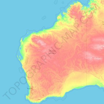
Name: Western Australia topographic map, elevation, terrain.
Location: Western Australia, Australia (-35.24185 112.86567 -13.50769 129.00205)
Average elevation: 194 m
Minimum elevation: -2 m
Maximum elevation: 1,208 m
Make a donation
Other topographic maps
Click on a map to view its topography, its elevation and its terrain.
Make a donation
Make a donation
Make a donation
Make a donation