
Thank you for supporting this site ❤️
Make a donation
Make a donation
Morvan topographic map
Click on the map to display elevation.
Thank you for supporting this site ❤️
Make a donation
Make a donation
Morvan
It is the smallest mountain area in France in terms of landmass covered, as well as the lowest, with a maximum altitude of 901 metres (2,956 feet) at Haut-Folin.
Thank you for supporting this site ❤️
Make a donation
Make a donation
About this map
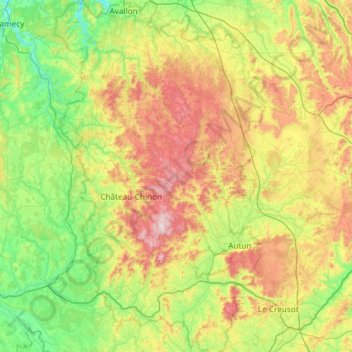
Name: Morvan topographic map, elevation, terrain.
Location: Morvan, Bourgogne-Franche-Comté, Metropolitan France, France (46.74221 3.58498 47.52833 4.49478)
Average elevation: 368 m
Minimum elevation: 133 m
Maximum elevation: 904 m
Thank you for supporting this site ❤️
Make a donation
Make a donation