
Thank you for supporting this site ❤️
Make a donation
Make a donation
Elköy topographic map
Click on the map to display elevation.
Thank you for supporting this site ❤️
Make a donation
Make a donation
About this map
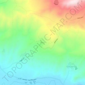
Name: Elköy topographic map, elevation, terrain.
Location: Elköy, Çorum, Black Sea Region, Turkey (40.35336 35.08099 40.39336 35.12099)
Average elevation: 828 m
Minimum elevation: 635 m
Maximum elevation: 1,181 m
Thank you for supporting this site ❤️
Make a donation
Make a donation
Other topographic maps
Click on a map to view its topography, its elevation and its terrain.
Bayat Mahallesi
Çorum (Turkish pronunciation: [ˈtʃoɾum]) (Medieval Greek: Ευχάνεια, romanized: Euchaneia) is a northern Anatolian city in Turkey. Çorum is located inland in the central Black Sea Region of Turkey and is approximately 244 km (152 mi) from Ankara and 608 km (378 mi) from Istanbul. It is the seat of…
Average elevation: 824 m