
Make a donation
Lourmarin topographic map
Click on the map to display elevation.
Make a donation
About this map
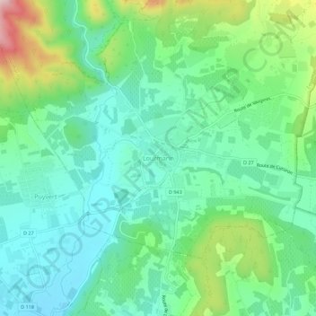
Name: Lourmarin topographic map, elevation, terrain.
Average elevation: 259 m
Minimum elevation: 156 m
Maximum elevation: 531 m
Make a donation
Other topographic maps
Click on a map to view its topography, its elevation and its terrain.
Make a donation
Make a donation
Make a donation
Make a donation
Make a donation
Avignon
France > Provence-Alpes-Côte d'Azur > Vaucluse
Enclosed by the city walls, the Rocher des Doms is a limestone elevation of Urgonian type, 35 metres high (and therefore safe from flooding of the Rhone which it overlooks) and is the original core of the city. Several limestone massifs are present around the commune (the Massif des Angles,…
Average elevation: 39 m
Make a donation
Make a donation
Make a donation
Monieux
France > Provence-Alpes-Côte d'Azur > Vaucluse
The commune is located in the zone of influence of the Mediterranean climate. The summers are hot and dry, related to the increase in altitude of the subtropical anticyclones, intersected with stormy episodes sometimes violent one. The winters are soft. Precipitations are not very frequent and rare snow. It…
Average elevation: 810 m
Make a donation
Le Rhône - Bras Mort de la Barthelasse
France > Provence-Alpes-Côte d'Azur > Vaucluse > Avignon
Average elevation: 24 m
Avignon
France > Provence-Alpes-Côte d'Azur > Vaucluse
Enclosed by the city walls, the Rocher des Doms is a limestone elevation of Urgonian type, 35 metres high (and therefore safe from flooding of the Rhone which it overlooks) and is the original core of the city. Several limestone massifs are present around the commune (the Massif des Angles,…
Average elevation: 39 m
Make a donation
Avignon
France > Provence-Alpes-Côte d'Azur > Vaucluse
Enclosed by the city walls, the Rocher des Doms is a limestone elevation of Urgonian type, 35 metres high[18] (and therefore safe from flooding of the Rhone which it overlooks) and is the original core of the city. Several limestone massifs are present around the commune (the Massif des Angles,…
Average elevation: 39 m
Make a donation
Make a donation
Make a donation
Make a donation