
Make a donation
Matavun topographic map
Click on the map to display elevation.
Make a donation
About this map
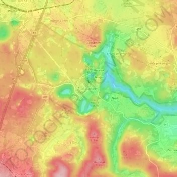
Name: Matavun topographic map, elevation, terrain.
Location: Matavun, Divača, Upravna enota Sežana, 6215, Slovenia (45.64287 13.97020 45.68287 14.01020)
Average elevation: 436 m
Minimum elevation: 325 m
Maximum elevation: 521 m
Make a donation
Other topographic maps
Click on a map to view its topography, its elevation and its terrain.
Triglav National Park
Systematic surveys of plants, especially of ethnobotanically useful species, in Triglav National Park have been carried out by Chandra Prakash Kala and Petra Ratajc covering various microhabitats, elevations, aspects, and terrain types. The park has over fifty-nine species of ethnobotanical values, of these 37…
Average elevation: 1,063 m
Make a donation
Make a donation
Make a donation
Make a donation
Soča
An Alpine river in character, its source lies in the Trenta Valley in the Julian Alps in northwestern Slovenia, at an elevation of 876 metres (2,874 ft). The river runs past the towns of Bovec, Kobarid, Tolmin, Kanal ob Soči, Nova Gorica (where it is crossed by the Solkan Bridge), and Gorizia, entering the…
Average elevation: 622 m
Make a donation
Make a donation
Make a donation
Soča
An Alpine river in character, its source lies in the Trenta Valley in the Julian Alps in northwestern Slovenia, at an elevation of 876 metres (2,874 ft). The river runs past the towns of Bovec, Kobarid, Tolmin, Kanal ob Soči, Nova Gorica (where it is crossed by the Solkan Bridge), and Gorizia, entering the…
Average elevation: 562 m
Make a donation
Make a donation
Make a donation
Make a donation