
Santa Fe County topographic map
Interactive map
Click on the map to display elevation.
About this map
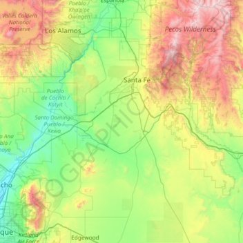
Name: Santa Fe County topographic map, elevation, terrain.
Location: Santa Fe County, New Mexico, United States of America (35.04056 -106.24922 36.00449 -105.71456)
Average elevation: 2,177 m
Minimum elevation: 1,527 m
Maximum elevation: 3,974 m
Other topographic maps
Click on a map to view its topography, its elevation and its terrain.
Taos County
United States of America > New Mexico
Taos County, New Mexico, United States of America
Average elevation: 2,561 m
Doña Ana County
United States of America > New Mexico
Doña Ana County, New Mexico, United States of America
Average elevation: 1,349 m