
Make a donation
Bogor topographic map
Click on the map to display elevation.
Make a donation
Bogor
The city is situated in the western part of Java island, about 53 km south of the capital Jakarta and 85 km northwest of Bandung, the administrative center of West Java Province. Bogor spreads over a basin near volcanoes Salak, which peaks at about 12 km south, and Mount Gede whose top is 22–25 km south-east of the city. The average elevation is 265 meters, maximum 330 m, and minimum 190 meters above sea level. The terrain is rather uneven: 17.64 km2 of its area has slopes of 0–2°, 80.9 km2 from 2° to 15°, 11 km2 between 15° and 25°, 7.65 km2 from 25° to 40° and 1.20 km2 over 40°; the northern part is relatively flat and the southern part is more hilly.
Make a donation
About this map
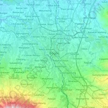
Name: Bogor topographic map, elevation, terrain.
Location: Bogor, West Java, Java, Indonesia (-6.68131 106.73484 -6.51433 106.84852)
Average elevation: 310 m
Minimum elevation: 129 m
Maximum elevation: 1,145 m
Make a donation
Other topographic maps
Click on a map to view its topography, its elevation and its terrain.
Make a donation
Make a donation
Make a donation
Make a donation
Make a donation
Make a donation
Make a donation
Bekasi
The City of Bekasi is a part of the Bekasi river basin, located in the downstream area of the basin with slopes ranging from 0 to 2% and elevations between 11 meters to 81 meters above sea level. This topographical condition leads to frequent flooding in many areas of Bekasi, especially during the rainy…
Average elevation: 23 m
Make a donation
Make a donation
Make a donation
Make a donation
DUSUN IV DESA MUKAPAYUNG KEC. CILILIN KAB. BANDUNG BARAT
Indonesia > West Java > West Bandung
Average elevation: 918 m
Make a donation
Make a donation
Make a donation
Make a donation
Make a donation
Make a donation
Make a donation
Make a donation
Make a donation
Make a donation
Ngamprah
Indonesia > West Java > West Bandung
Ngamprah has an elevation moderated tropical rainforest climate (Af) with moderate rainfall from June to September and heavy rainfall from October to May.
Average elevation: 803 m
Make a donation
Megamendung
Much of the district lies at an elevation of 500-600 metres, which moderates the temperature, and causing contrast to the heat of Greater Jakarta and other adjacent low-lying lands. Though much of the built-up area is not necessarily on rugged terrain, uneven ground is the most common terrain as it stands…
Average elevation: 776 m
Ngamprah
Indonesia > West Java > West Bandung
Ngamprah has an elevation moderated tropical rainforest climate (Af) with moderate rainfall from June to September and heavy rainfall from October to May.
Average elevation: 803 m
Make a donation
Make a donation
Mount Salak
Mount Salak is popular for many mountain climbing clubs, especially Route II, because of the difficulty involved in reaching the peak. Climbers bring water with them, especially through Post I at Kawah Ratu Route. A water source, supplied by rain, exists at an altitude of 2,211 m (7,254 ft) on this route.
Average elevation: 1,770 m
Make a donation