
Thank you for supporting this site ❤️
Make a donation
Make a donation
Nieul-sur-Mer topographic map
Click on the map to display elevation.
Thank you for supporting this site ❤️
Make a donation
Make a donation
About this map
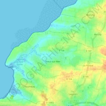
Name: Nieul-sur-Mer topographic map, elevation, terrain.
Average elevation: 12 m
Minimum elevation: -4 m
Maximum elevation: 34 m
Thank you for supporting this site ❤️
Make a donation
Make a donation
Other topographic maps
Click on a map to view its topography, its elevation and its terrain.
La Chataignerie
France > Nouvelle-Aquitaine > Charente-Maritime > Plassay > Conchamp
Average elevation: 51 m
Thank you for supporting this site ❤️
Make a donation
Make a donation
Pièce du Moulin
France > Nouvelle-Aquitaine > Charente-Maritime > Le Grand-Village-Plage
Average elevation: 4 m
Thank you for supporting this site ❤️
Make a donation
Make a donation
Thank you for supporting this site ❤️
Make a donation
Make a donation
Marennes-Plage
France > Nouvelle-Aquitaine > Charente-Maritime > Marennes-Hiers-Brouage
Average elevation: 3 m
Le Moulin de Dore
France > Nouvelle-Aquitaine > Charente-Maritime > Barzan-Plage > Chez Pilou
Average elevation: 9 m
Thank you for supporting this site ❤️
Make a donation
Make a donation
Le Pérat
France > Nouvelle-Aquitaine > Charente-Maritime > Saint-Bonnet-sur-Gironde
Average elevation: 19 m
Thank you for supporting this site ❤️
Make a donation
Make a donation