
Thank you for supporting this site ❤️
Make a donation
Make a donation
Bielsko-Biała topographic map
Click on the map to display elevation.
Thank you for supporting this site ❤️
Make a donation
Make a donation
About this map
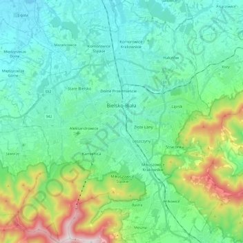
Name: Bielsko-Biała topographic map, elevation, terrain.
Location: Bielsko-Biała, Silesian Voivodeship, Poland (49.73668 18.94538 49.88744 19.13218)
Average elevation: 439 m
Minimum elevation: 246 m
Maximum elevation: 1,109 m
Thank you for supporting this site ❤️
Make a donation
Make a donation
Other topographic maps
Click on a map to view its topography, its elevation and its terrain.
Thank you for supporting this site ❤️
Make a donation
Make a donation
Thank you for supporting this site ❤️
Make a donation
Make a donation