
Thank you for supporting this site ❤️
Make a donation
Make a donation
Freux topographic map
Click on the map to display elevation.
Thank you for supporting this site ❤️
Make a donation
Make a donation
About this map
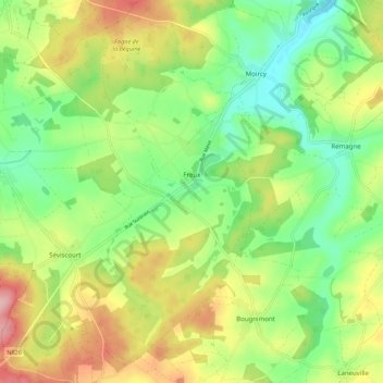
Name: Freux topographic map, elevation, terrain.
Average elevation: 477 m
Minimum elevation: 410 m
Maximum elevation: 574 m
Thank you for supporting this site ❤️
Make a donation
Make a donation
Other topographic maps
Click on a map to view its topography, its elevation and its terrain.
Tombeau Du Géant
Belgium > Luxembourg > Neufchâteau > Bouillon > Ucimont > Botassart
Average elevation: 300 m