
Make a donation
Bikfaya topographic map
Click on the map to display elevation.
Make a donation
Bikfaya
Bikfaya is nestled in the mountains overlooking the Mediterranean with an elevation ranging from 900 to 1000 meters above sea level. It lies 25 km from Beirut and only a short drive to the Mzaar-Kfardebian ski resort and Zaarour Club. Summers in Bikfaya are cool and characterized by periods of fog in the afternoon.
Make a donation
About this map
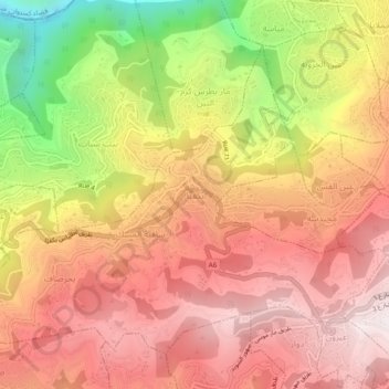
Name: Bikfaya topographic map, elevation, terrain.
Average elevation: 843 m
Minimum elevation: 169 m
Maximum elevation: 1,269 m
Make a donation
Other topographic maps
Click on a map to view its topography, its elevation and its terrain.
Aley
Lebanon > Mount Lebanon Governorate
The word "Aley" means "high place" in Arabic and in Aramaic, referring to the city's high altitude above sea level (from 600m up to 950m).
Average elevation: 775 m
Make a donation
Make a donation
Make a donation
Make a donation
Make a donation
Make a donation
Dik El Mehdeh
Lebanon > Mount Lebanon Governorate
Dik El Mehdi (Arabic: ديك المحدي) is a village, at 325 meters elevation, in the Matn District governorate of Mount Lebanon. Its population has been estimated at 2,096 by Aayroun. The village is around 18 km. from Beirut. The majority of it inhabitants derives from the Ashkar family. Many of its…
Average elevation: 246 m
Make a donation
Make a donation
Make a donation
Make a donation
Baskinta
Lebanon > Mount Lebanon Governorate
Baskinta (Arabic: بسكنتا) is a Lebanese village situated at an altitude ranging from 1250 metres above sea level and climbs up to approximately 1800 meters of height at Qanat Bakish, making it one of the highest villages of Lebanon. It is located 43 kilometers north east of Beirut.
Average elevation: 1,396 m
Make a donation
Make a donation
Make a donation
Make a donation
Make a donation
Baskinta
Lebanon > Mount Lebanon Governorate
Baskinta (Arabic: بسكنتا) is a Lebanese village situated at an altitude ranging from 1250 metres above sea level and climbs up to approximately 1800 meters of height at Qanat Bakish, making it one of the highest villages of Lebanon. It is located 43 kilometers north east of Beirut.
Average elevation: 1,396 m
Make a donation
Make a donation
Make a donation
Ain Saadeh
Lebanon > Mount Lebanon Governorate
The average annual rainfall is 825 millimetres (32.5 in), with the large majority of it falling from October to April. Much of the autumn and spring rain falls in heavy downpours on a limited number of days, but in winter it is spread more evenly over many days. Summer receives very little rainfall, if any.…
Average elevation: 335 m
Make a donation
Antelias
Lebanon > Mount Lebanon Governorate
The municipality of Antelias - Naqqach is located in the Kaza of Matn in Mount Lebanon, one of the eight mohafazats (governorates) of Lebanon. Antelias - Naqqach is 8 kilometers (4.9712 mi) from Beyrouth (Beirut), the capital of Lebanon. Its elevation is 10 meters (32.81 ft; 10.936 yd) above sea level.…
Average elevation: 65 m
Make a donation
Aley
Lebanon > Mount Lebanon Governorate
The word "Aley" means "high place" in Arabic and in Aramaic, referring to the city's high altitude above sea level (from 600m up to 950m).
Average elevation: 775 m
Make a donation
Make a donation
Aley
Lebanon > Mount Lebanon Governorate
The word "Aley" means "high place" in Arabic and in Aramaic, referring to the city's high altitude above sea level (from 600m up to 950m).
Average elevation: 775 m
Make a donation