
Make a donation
Chaco topographic map
Click on the map to display elevation.
Make a donation
Chaco
Chaco Province covers an area of 99,633 km2 (38,469 sq mi) and ranks as the twelfth largest Argentinian province. The highest ground in the province is also the most western, near the municipality of Taco Pozo, at an elevation of 272 m (892 ft) above sea level.
Make a donation
About this map
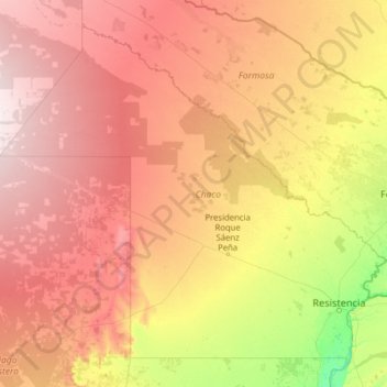
Name: Chaco topographic map, elevation, terrain.
Location: Chaco, Argentina (-28.06872 -63.42247 -24.07925 -58.37451)
Average elevation: 125 m
Minimum elevation: 37 m
Maximum elevation: 282 m
Make a donation
Other topographic maps
Click on a map to view its topography, its elevation and its terrain.
Andes
Argentina > Mendoza > Distrito Las Cuevas
The Andes Mountains are the highest mountain range outside Asia. The highest mountain outside Asia, Argentina's Mount Aconcagua, rises to an elevation of about 6,961 m (22,838 ft) above sea level. The peak of Chimborazo in the Ecuadorian Andes is farther from the Earth's center than any other location on the…
Average elevation: 6,208 m
Make a donation
Make a donation
Make a donation
Make a donation
Piedra del Águila
Argentina > Neuquén Province > Municipio de Piedra del Águila
Average elevation: 539 m
Make a donation