
Thank you for supporting this site ❤️
Make a donation
Make a donation
Zagreb topographic map
Click on the map to display elevation.
Thank you for supporting this site ❤️
Make a donation
Make a donation
Zagreb
Zagreb (/ˈzɑːɡrɛb/ ZAH-greb Croatian: [zǎːɡreb] ) is the capital and largest city of Croatia. It is in the north of the country, along the Sava river, at the southern slopes of the Medvednica mountain. Zagreb stands near the international border between Croatia and Slovenia at an elevation of approximately 158 m (518 ft) above sea level. At the 2021 census, the city itself had a population of 767,131, while the population of Zagreb urban agglomeration is slightly above one million people.
Thank you for supporting this site ❤️
Make a donation
Make a donation
About this map
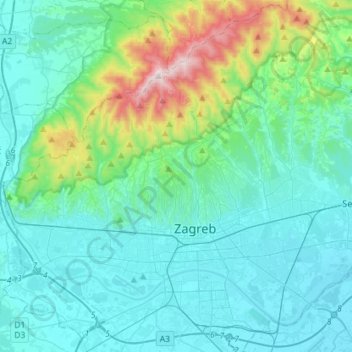
Name: Zagreb topographic map, elevation, terrain.
Location: Zagreb, City of Zagreb, Croatia (45.74601 15.82171 45.93930 16.10701)
Average elevation: 249 m
Minimum elevation: 100 m
Maximum elevation: 1,027 m
Thank you for supporting this site ❤️
Make a donation
Make a donation