
Thank you for supporting this site ❤️
Make a donation
Make a donation
Dereiçi topographic map
Click on the map to display elevation.
Thank you for supporting this site ❤️
Make a donation
Make a donation
About this map
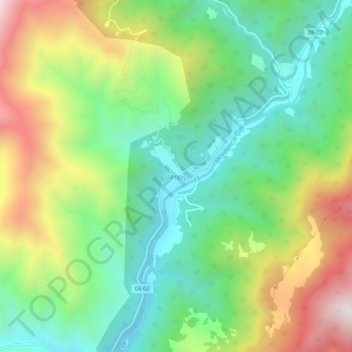
Name: Dereiçi topographic map, elevation, terrain.
Location: Dereiçi, Şavşat, Artvin, Black Sea Region, Turkey (41.30660 42.21607 41.34660 42.25607)
Average elevation: 1,091 m
Minimum elevation: 708 m
Maximum elevation: 1,743 m
Thank you for supporting this site ❤️
Make a donation
Make a donation
Other topographic maps
Click on a map to view its topography, its elevation and its terrain.
Karagöl Sahara National Park
The national park covers an area of 3,251 ha (8,030 acres) at an average elevation of 1,800 m (5,900 ft) above mean sea level.
Average elevation: 1,885 m