
Thank you for supporting this site ❤️
Make a donation
Make a donation
Sevry topographic map
Click on the map to display elevation.
Thank you for supporting this site ❤️
Make a donation
Make a donation
About this map
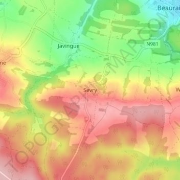
Name: Sevry topographic map, elevation, terrain.
Location: Sevry, Beauraing, Dinant, Namur, Wallonia, 5570, Belgium (50.07197 4.90624 50.11197 4.94624)
Average elevation: 275 m
Minimum elevation: 181 m
Maximum elevation: 356 m
Thank you for supporting this site ❤️
Make a donation
Make a donation
Other topographic maps
Click on a map to view its topography, its elevation and its terrain.