
Thank you for supporting this site ❤️
Make a donation
Make a donation
Ninh Hòa topographic map
Click on the map to display elevation.
Thank you for supporting this site ❤️
Make a donation
Make a donation
About this map
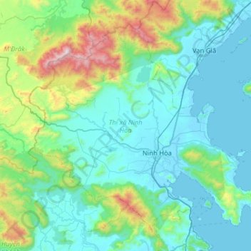
Name: Ninh Hòa topographic map, elevation, terrain.
Location: Ninh Hòa, Xã Tân Định, Khánh Hòa Province, 57000, Vietnam (12.34282 108.87157 12.75386 109.38054)
Average elevation: 323 m
Minimum elevation: -2 m
Maximum elevation: 1,974 m
Thank you for supporting this site ❤️
Make a donation
Make a donation