
Thank you for supporting this site ❤️
Make a donation
Make a donation
Ras Jebel topographic map
Click on the map to display elevation.
Thank you for supporting this site ❤️
Make a donation
Make a donation
Ras Jebel
Ras Jebel is set on a hill overlooking the Mediterranean Sea. It has an altitude of 53 meters (174 ft).
Thank you for supporting this site ❤️
Make a donation
Make a donation
About this map
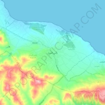
Name: Ras Jebel topographic map, elevation, terrain.
Average elevation: 62 m
Minimum elevation: -2 m
Maximum elevation: 260 m
Thank you for supporting this site ❤️
Make a donation
Make a donation