
Make a donation
Mount Narodnaya topographic map
Click on the map to display elevation.
Make a donation
Mount Narodnaya
Mount Narodnaya (also known as Naroda and Poenurr; Russian: гора Народная, Komi: Народа-Из ("People's Mountain"), Mansi: Поэӈ-ур, Поэн-урр) is the highest peak of the Urals in Russia. Its elevation is 1,894 metres (6,214 ft). It is located on the border between Khanty–Mansi Autonomous Okrug in Tyumen Oblast and Komi Republic, the highest point being 0.5 km to the east from the border. The name may refer to Naroda River, which originates from the mount, located in the Research Range.
Make a donation
About this map
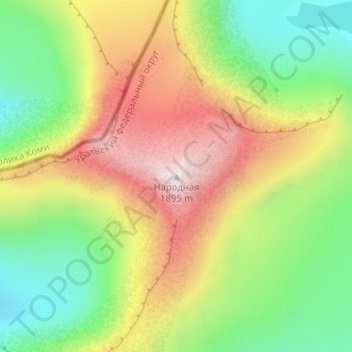
Name: Mount Narodnaya topographic map, elevation, terrain.
Average elevation: 1,437 m
Minimum elevation: 1,096 m
Maximum elevation: 1,893 m
Make a donation
Other topographic maps
Click on a map to view its topography, its elevation and its terrain.
Шайтанка
Russia > Khanty-Mansiysk Autonomous Okrug – Ugra > Beryozovsky District > Beryozovo
Average elevation: 24 m
Хурумпауль
Russia > Khanty-Mansiysk Autonomous Okrug – Ugra > Beryozovsky District
Average elevation: 21 m
Сохсъя
Russia > Khanty-Mansiysk Autonomous Okrug – Ugra > Beryozovsky District
Average elevation: 30 m