
Thank you for supporting this site ❤️
Make a donation
Make a donation
Säffle kommun topographic map
Click on the map to display elevation.
Thank you for supporting this site ❤️
Make a donation
Make a donation
About this map
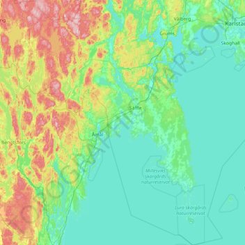
Name: Säffle kommun topographic map, elevation, terrain.
Location: Säffle kommun, Värmland County, Sweden (58.72533 12.41507 59.44795 13.58883)
Average elevation: 89 m
Minimum elevation: 40 m
Maximum elevation: 304 m
Thank you for supporting this site ❤️
Make a donation
Make a donation
Other topographic maps
Click on a map to view its topography, its elevation and its terrain.
Thank you for supporting this site ❤️
Make a donation
Make a donation
Thank you for supporting this site ❤️
Make a donation
Make a donation
Thank you for supporting this site ❤️
Make a donation
Make a donation
Thank you for supporting this site ❤️
Make a donation
Make a donation
Höljes
Due to the frost hollow aspects of its topography, Höljes has received frosts in every single month of the year. Even so, due to climate change summer frosts have become rarer events although those sometimes occur. The annual low temperature is averaging below freezing and the diurnal temperature variation is…
Average elevation: 333 m
Thank you for supporting this site ❤️
Make a donation
Make a donation