
Thank you for supporting this site ❤️
Make a donation
Make a donation
Sankt Englmar topographic map
Click on the map to display elevation.
Thank you for supporting this site ❤️
Make a donation
Make a donation
About this map
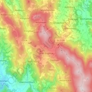
Name: Sankt Englmar topographic map, elevation, terrain.
Average elevation: 712 m
Minimum elevation: 363 m
Maximum elevation: 1,081 m
Thank you for supporting this site ❤️
Make a donation
Make a donation
Other topographic maps
Click on a map to view its topography, its elevation and its terrain.
Thank you for supporting this site ❤️
Make a donation
Make a donation
Westen
Germany > Bavaria > Landkreis Straubing-Bogen > Mallersdorf-Pfaffenberg
Average elevation: 410 m
Thank you for supporting this site ❤️
Make a donation
Make a donation