
Make a donation
Jablanica topographic map
Click on the map to display elevation.
Make a donation
Jablanica
The mean elevation of Jablanica is 202 metres (663 ft) above sea level. Some 69% of the municipalities 301 km2 (116 sq mi) of area is forested. The Jablanica lake is an important geographical as well as economic presence in Jablanica.
Make a donation
About this map
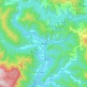
Name: Jablanica topographic map, elevation, terrain.
Average elevation: 468 m
Minimum elevation: 153 m
Maximum elevation: 1,499 m
Make a donation
Other topographic maps
Click on a map to view its topography, its elevation and its terrain.
Zenica
Bosnia and Herzegovina > Federation of Bosnia and Herzegovina > City of Zenica
The city is geographically located in the heart of Bosnia. The settled area is 43.01 km2 (16.61 mi2) and of the city proper covers 558.5 km2 (215.6 mi2). Elevation is 310–350 m (1,017–1,148 ft). The rivers Bosna, Lašva, Babina, and Kočeva flow through the settlement. A moderate continental climate…
Average elevation: 555 m
Mostar
Bosnia and Herzegovina > Federation of Bosnia and Herzegovina > City of Mostar
Average elevation: 221 m
Make a donation
Pivnice
Bosnia and Herzegovina > Federation of Bosnia and Herzegovina > City of Cazin > Pivnice
Average elevation: 379 m
Svrake
Bosnia and Herzegovina > Federation of Bosnia and Herzegovina > Svrake
Average elevation: 639 m
Bihać
Bosnia and Herzegovina > Federation of Bosnia and Herzegovina > City of Bihać
Average elevation: 368 m
Make a donation
Bjelašnica
Bosnia and Herzegovina > Federation of Bosnia and Herzegovina > City of Istočno Sarajevo
Bjelašnica (Serbian Cyrillic: Бјелашница, pronounced [bjělaːʃnit͡sa]) is a mountain in the Dinaric Alps in central Bosnia and Herzegovina. It is to the southwest of Sarajevo, bordering Mount Igman. Bjelašnica's tallest peak, by which the mountain group got its name, rises to an elevation of…
Average elevation: 1,097 m
Rujnica
Bosnia and Herzegovina > Federation of Bosnia and Herzegovina > City of Cazin > Rujnica
Average elevation: 303 m
Dinara
Bosnia and Herzegovina > Federation of Bosnia and Herzegovina > City of Livno
Average elevation: 952 m
Make a donation
Sana
Bosnia and Herzegovina > Federation of Bosnia and Herzegovina
After 72 km and the altitude difference of 262.52 m, the Sana then passes through Sanski Most and combines with two significant tributary rivers, the Zdena and the Bliha river, both from the left, as well as the smaller Majdanuša from the left. From here it runs toward the town of Prijedor, where its middle…
Average elevation: 570 m
Make a donation
Tržac
Bosnia and Herzegovina > Federation of Bosnia and Herzegovina > City of Cazin > Tržac
Average elevation: 281 m
Bihać
Bosnia and Herzegovina > Federation of Bosnia and Herzegovina > City of Bihać
Average elevation: 368 m
Make a donation
Neretva
Bosnia and Herzegovina > Federation of Bosnia and Herzegovina
Its source and headwaters gorge are situated deep in the Dinaric Alps at the base of the Zelengora and Lebršnik mountains, specifically under the Gredelj saddle. The river source is at 1,227 meters above sea level and consists of five small and distinct wellsprings. On its 90 kilometers course through the…
Average elevation: 786 m
Sarajevo
Bosnia and Herzegovina > Federation of Bosnia and Herzegovina > City of Sarajevo
Average elevation: 817 m
Mostar
Bosnia and Herzegovina > Federation of Bosnia and Herzegovina > City of Mostar
Average elevation: 221 m
Make a donation
Igman
Bosnia and Herzegovina > Federation of Bosnia and Herzegovina > City of Istočno Sarajevo
Igman (Serbian Cyrillic: Игман, pronounced [îɡman]) is a mountain plateau in central Bosnia and Herzegovina. Geologically, Igman is part of the Dinaric Alps and formed largely of secondary and tertiary sedimentary rock, mostly Limestone. It is located southwest of Sarajevo, bordering the Bjelašnica…
Average elevation: 895 m
Dinara
Bosnia and Herzegovina > Federation of Bosnia and Herzegovina > City of Livno
Average elevation: 952 m
Bihać
Bosnia and Herzegovina > Federation of Bosnia and Herzegovina > City of Bihać
Average elevation: 368 m
Make a donation
Ključ Municipality
Bosnia and Herzegovina > Federation of Bosnia and Herzegovina
Average elevation: 604 m
Semizovac
Bosnia and Herzegovina > Federation of Bosnia and Herzegovina > Semizovac
Average elevation: 579 m
Poprati
Bosnia and Herzegovina > Federation of Bosnia and Herzegovina > Town of Stolac
Average elevation: 142 m
Make a donation
Bjelašnica
Bosnia and Herzegovina > Federation of Bosnia and Herzegovina > City of Istočno Sarajevo
Average elevation: 1,098 m
Bjelašnica
Bosnia and Herzegovina > Federation of Bosnia and Herzegovina > City of Istočno Sarajevo
Average elevation: 1,098 m
Sarajevo
Bosnia and Herzegovina > Federation of Bosnia and Herzegovina > City of Sarajevo
Average elevation: 750 m
Make a donation
Zaljut
Bosnia and Herzegovina > Federation of Bosnia and Herzegovina > Zaljut
Average elevation: 897 m
Centar Municipality
Bosnia and Herzegovina > Federation of Bosnia and Herzegovina > City of Sarajevo
Average elevation: 857 m
Sarajevo
Bosnia and Herzegovina > Federation of Bosnia and Herzegovina > City of Sarajevo
Average elevation: 750 m
Make a donation
Bihać
Bosnia and Herzegovina > Federation of Bosnia and Herzegovina > City of Bihać
Average elevation: 368 m
Sarajevo
Bosnia and Herzegovina > Federation of Bosnia and Herzegovina > City of Sarajevo
Average elevation: 750 m
Sarajevo
Bosnia and Herzegovina > Federation of Bosnia and Herzegovina > City of Sarajevo
Average elevation: 750 m
Una
Bosnia and Herzegovina > Federation of Bosnia and Herzegovina
The source of the Una river is located near the Croatian village of Donja Suvaja and consists of multiple smaller springs. The largest spring by discharge is a large karst spring at an elevation of 396 m (1,299 ft) above sea level, called Vrelo Une, and is considered to be the main spring of the river. The…
Average elevation: 499 m
Make a donation
Igman
Bosnia and Herzegovina > Federation of Bosnia and Herzegovina > City of Istočno Sarajevo
Igman (Serbian Cyrillic: Игман, pronounced [îɡman]) is a mountain plateau in central Bosnia and Herzegovina. Geologically, Igman is part of the Dinaric Alps and formed largely of secondary and tertiary sedimentary rock, mostly Limestone. It is located southwest of Sarajevo, bordering the Bjelašnica…
Average elevation: 895 m
Sarajevo
Bosnia and Herzegovina > Federation of Bosnia and Herzegovina > City of Sarajevo
Average elevation: 750 m
Make a donation
Bihać
Bosnia and Herzegovina > Federation of Bosnia and Herzegovina > City of Bihać
Average elevation: 368 m
Sarajevo
Bosnia and Herzegovina > Federation of Bosnia and Herzegovina > City of Sarajevo
Average elevation: 750 m
Mostar
Bosnia and Herzegovina > Federation of Bosnia and Herzegovina > City of Mostar
Average elevation: 221 m
Make a donation
Sarajevo
Bosnia and Herzegovina > Federation of Bosnia and Herzegovina > City of Sarajevo
Average elevation: 750 m
Mostar
Bosnia and Herzegovina > Federation of Bosnia and Herzegovina > City of Mostar
Average elevation: 221 m
Bihać
Bosnia and Herzegovina > Federation of Bosnia and Herzegovina > City of Bihać
Average elevation: 368 m
Make a donation