
Make a donation
La Pampa topographic map
Click on the map to display elevation.
Make a donation
La Pampa
Being located in the Pampas, the province has a cool temperate climate. In general, the province is dominated by two different types of climates: a temperate one in the east and a semi-arid one in the west. Precipitation generally decreases from east to west and from north to south. Being characterized by large thermal amplitudes, the climate of the province has continental characteristics, particularly in the west where thermal amplitudes are much larger. The general atmospheric circulation is one of the most important factors that influence the climate on a regional scale. During summer, the South Atlantic High is displaced to the southeast, which brings hot and humid air masses from the north and northeast. The South Pacific High in summer is responsible for bringing cooler air masses from the southwest which when these two contrasting air masses meet lead to precipitation occurring. In contrast, winters are dry due to the northward displacement of the South Atlantic high and the topographic barrier of the Andes north of 40oS which prevents frontal systems that bring precipitation from reaching the province. Any winds from the southwest during winter bring in cold and dry weather since most of the precipitation and humidity are released in the Andes. As such, most of the precipitation occurs during summer.
Make a donation
About this map
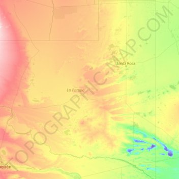
Name: La Pampa topographic map, elevation, terrain.
Location: La Pampa, Argentina (-39.32980 -68.29677 -35.00226 -63.38265)
Average elevation: 262 m
Minimum elevation: -45 m
Maximum elevation: 1,131 m
Make a donation
Other topographic maps
Click on a map to view its topography, its elevation and its terrain.
Cerro El Plata
Argentina > Mendoza > Distrito La Carrera
Cerro El Plata is the highest peak of the Cordón del Plata which is a subrange of the Andes. The mountain is located 65 kilometres (40 miles) southeast of Aconcagua and 60 kilometres (37 miles) west of the provincial capital, the city of Mendoza. Precipitation runoff from the mountains drains into the Mendoza…
Average elevation: 5,374 m
Make a donation
Make a donation
Make a donation
Andes
Argentina > Mendoza > Distrito Las Cuevas
The Andes Mountains are the highest mountain range outside Asia. The highest mountain outside Asia, Argentina's Mount Aconcagua, rises to an elevation of about 6,961 m (22,838 ft) above sea level. The peak of Chimborazo in the Ecuadorian Andes is farther from the Earth's center than any other location on the…
Average elevation: 6,208 m
Make a donation
Make a donation
Make a donation
Make a donation
Make a donation
Nevado de Cachi
Nevado de Cachi is the name given to a large complex of mountains that lies in Salta Province, Argentina. This complex counts several summits, the highest being 6,380m and it is called Cumbre Libertador. This summit was climbed for the first time in 1950. The mountains overlook Cachi, a traditional village of…
Average elevation: 5,900 m
Make a donation
Piedra del Águila
Argentina > Neuquén Province > Municipio de Piedra del Águila
Average elevation: 539 m
Make a donation
Make a donation
Campo de Mayo
Argentina > Chaco > Municipio de Juan José Castelli > Campo de Mayo
Average elevation: 118 m
Make a donation
Luján de Cuyo
Argentina > Mendoza > Departamento Luján de Cuyo > Luján de Cuyo
Average elevation: 951 m
Make a donation
General San Martín
Argentina > Buenos Aires > General San Martín > General San Martín
Average elevation: 25 m
Make a donation
Make a donation
Observatorio Parroquial
Argentina > Córdoba > Pedanía Sacanta > Las Varillas > Las Varillas
Average elevation: 136 m
Make a donation
Cerro del Bolsón
While not of great height compared to the 6000 metre-plus peaks of the main chain of the Andes to the west, Bolsón is notable for its high topographic prominence (it ranks 69th in the world), resulting from its separation from the main chain by a relatively low saddle.
Average elevation: 5,057 m