
Thank you for supporting this site ❤️
Make a donation
Make a donation
Furth im Wald topographic map
Click on the map to display elevation.
Thank you for supporting this site ❤️
Make a donation
Make a donation
About this map
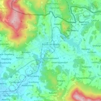
Name: Furth im Wald topographic map, elevation, terrain.
Location: Furth im Wald, Landkreis Cham, Bavaria, 93437, Germany (49.25136 12.74570 49.35095 12.91932)
Average elevation: 503 m
Minimum elevation: 373 m
Maximum elevation: 956 m
Thank you for supporting this site ❤️
Make a donation
Make a donation
Other topographic maps
Click on a map to view its topography, its elevation and its terrain.