
Make a donation
Anglet topographic map
Click on the map to display elevation.
Make a donation
Anglet
In 1557, the Saint Léon church was demolished and transferred to its current location in 1564 in front of the current town hall of Anglet. As Manex Goyhenetche points out in his book on Anglet, the city was then "the surrounding countryside of Bayonne", "densely populated rural suburb of peasants". It was more than a single entity, but a set of different districts including religious buildings (chapels) which have disappeared today. It was a large rural territory dominated by a topography of landforms (plateaus and terraces) and lower parts (Barthes and streams) covered various agricultural operations, woods, orchards, vineyards, and mills which lived on agriculture and cattle.
Make a donation
About this map
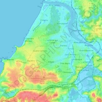
Name: Anglet topographic map, elevation, terrain.
Average elevation: 23 m
Minimum elevation: -3 m
Maximum elevation: 91 m
Make a donation
Other topographic maps
Click on a map to view its topography, its elevation and its terrain.
Col de la Pierre Saint-Martin
France > Nouvelle-Aquitaine > Pyrénées-Atlantiques > Arette
Col de la Pierre Saint-Martin (elevation 1,766 m (5,794 ft)) is a mountain pass on the France-Spain border in the western Pyrenees in the department of Pyrénées-Atlantiques (France) and Navarra (Spain). The climb from the Spanish side was used in the 2007 Tour de France.
Average elevation: 1,695 m
Make a donation
Alhahiri
France > Nouvelle-Aquitaine > Pyrénées-Atlantiques > Saint-Martin-d'Arrossa
Average elevation: 244 m
Urguri
France > Nouvelle-Aquitaine > Pyrénées-Atlantiques > Saint-Pée-sur-Nivelle
Average elevation: 65 m
Make a donation
Make a donation
Ibarrun
France > Nouvelle-Aquitaine > Pyrénées-Atlantiques > Saint-Pée-sur-Nivelle
Average elevation: 68 m