
Thank you for supporting this site ❤️
Make a donation
Make a donation
Dordogne topographic map
Click on the map to display elevation.
Thank you for supporting this site ❤️
Make a donation
Make a donation
About this map
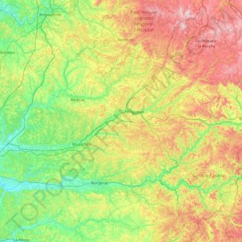
Name: Dordogne topographic map, elevation, terrain.
Location: Dordogne, Nouvelle-Aquitaine, Metropolitan France, France (44.57105 -0.04191 45.71480 1.44814)
Average elevation: 164 m
Minimum elevation: 3 m
Maximum elevation: 546 m
Thank you for supporting this site ❤️
Make a donation
Make a donation
Other topographic maps
Click on a map to view its topography, its elevation and its terrain.
La Fageole
France > Nouvelle-Aquitaine > Dordogne > Saint-Félix-de-Reillac-et-Mortemart
Average elevation: 213 m
Lavillemichel
France > Nouvelle-Aquitaine > Haute-Vienne > Bessines-sur-Gartempe
Average elevation: 349 m
Thank you for supporting this site ❤️
Make a donation
Make a donation
Laudibertie
France > Nouvelle-Aquitaine > Dordogne > Saint-Privat-en-Périgord > Festalemps
Average elevation: 93 m
Thank you for supporting this site ❤️
Make a donation
Make a donation