
Hergiswil (NW) topographic map
Interactive map
Click on the map to display elevation.
About this map
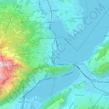
Name: Hergiswil (NW) topographic map, elevation, terrain.
Location: Hergiswil (NW), Nidwalden, 6052, Switzerland (46.97315 8.21809 46.99957 8.33445)
Average elevation: 676 m
Minimum elevation: 422 m
Maximum elevation: 2,094 m
Other topographic maps
Click on a map to view its topography, its elevation and its terrain.
ewl Ausgleichsbecken Untertrübsee
Switzerland > Nidwalden > Wolfenschiessen
Average elevation: 1,458 m
Bürgenstock
Switzerland > Nidwalden > Ennetbürgen
On the Dufourkarte (Dufour Map), the topographic map of Switzerland from 1844 to 1864, the mountain ridge as a whole had no name. The highest crest was referred to as Hametschwand.
Average elevation: 641 m