
Thank you for supporting this site ❤️
Make a donation
Make a donation
Peru topographic map
Click on the map to display elevation.
Thank you for supporting this site ❤️
Make a donation
Make a donation
About this map
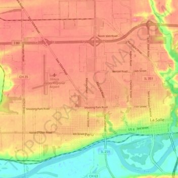
Name: Peru topographic map, elevation, terrain.
Location: Peru, LaSalle County, Illinois, 61354, United States (41.30951 -89.18308 41.38211 -89.10573)
Average elevation: 180 m
Minimum elevation: 132 m
Maximum elevation: 208 m
Thank you for supporting this site ❤️
Make a donation
Make a donation
Other topographic maps
Click on a map to view its topography, its elevation and its terrain.