
Thank you for supporting this site ❤️
Make a donation
Make a donation
Sysslebäck topographic map
Click on the map to display elevation.
Thank you for supporting this site ❤️
Make a donation
Make a donation
About this map
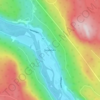
Name: Sysslebäck topographic map, elevation, terrain.
Location: Sysslebäck, Torsby kommun, Värmland County, Sweden (60.71043 12.85117 60.75043 12.89117)
Average elevation: 315 m
Minimum elevation: 148 m
Maximum elevation: 590 m
Thank you for supporting this site ❤️
Make a donation
Make a donation
Other topographic maps
Click on a map to view its topography, its elevation and its terrain.