
Urup topographic map
Interactive map
Click on the map to display elevation.
About this map
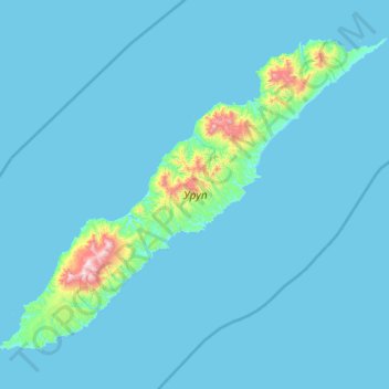
Name: Urup topographic map, elevation, terrain.
Average elevation: 54 m
Minimum elevation: 0 m
Maximum elevation: 1,397 m
Other topographic maps
Click on a map to view its topography, its elevation and its terrain.
Saratovskaya
Russia > Sakhalin Oblast > Yuzhno-Kurilsky District
Saratovskaya, Yuzhno-Kurilsky District, Sakhalin Oblast, Far Eastern Federal District, Russia
Average elevation: 80 m
Сноу
Сноу, Kurilsky District, Sakhalin Oblast, Far Eastern Federal District, Russia
Average elevation: 162 m
Paramushir
Paramushir, Severo-Kurilsky District, Sakhalin Oblast, Far Eastern Federal District, 694550, Russia
Average elevation: 94 m