
Jalisco topographic map
Click on the map to display elevation.
Jalisco
Jalisco is made up of a diverse terrain that includes forests, beaches, plains, and lakes. Altitudes in the state vary from 0 to 4,300 meters (0 to 14,110 ft) above sea level, from the coast to the top of the Nevado de Colima. The Jalisco area contains all five of Mexico's natural ecosystems: arid and semi arid scrublands, tropical evergreen forests, tropical deciduous and thorn forests, grasslands and mesquite grasslands, and temperate forests with oaks, pines and firs. Over 52% of the bird species found in Mexico live in the state, with 525, 40% of Mexico's mammals with 173 and 18% of its reptile species. There are also 7,500 species of veined plants. One reason for its biodiversity is that it lies in the transition area between the temperate north and tropical south. It also lies at the northern edge of the Sierra Madre del Sur and is on the Trans-Mexican Volcanic Belt, which provides a wide variety of ecological conditions from tropical rainforest conditions to semi arid areas to areas apt for conifer forests.
About this map
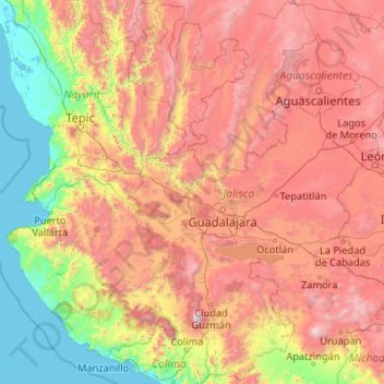
Name: Jalisco topographic map, elevation, terrain.
Location: Jalisco, Mexico (18.92587 -105.69540 22.75025 -101.51054)
Average elevation: 1,301 m
Minimum elevation: -2 m
Maximum elevation: 4,016 m
Other topographic maps
Click on a map to view its topography, its elevation and its terrain.
Toluca
Mexico > State of Mexico > Toluca
Toluca is located at 2600 meters above sea level, being the highest capital city in Mexico and North America, which makes it temperate throughout the year with average temperatures ranging between 6 and 25 degrees Celsius during spring and summer, and from −5 to 20 degrees Celsius in winter. Its climate is…
Average elevation: 2,729 m
Puebla City
Mexico > Puebla > Municipio de Puebla
The Sierra del Tentzon and higher elevations of Malinche volcano still conserve the Trans-Mexican Volcanic Belt pine-oak forests ecoregion – with forests of pine, holm oak and other tree species. In the pine forests, Montezuma Pine (Pinus montezumae) is generally predominant, with Hartweg's Pine (Pinus…
Average elevation: 2,233 m
Culiacán
Culiacán is located in the central region of the State of Sinaloa, forming part of the Northwest of Mexico. The coordinates that correspond to it are 24 ° 48'15 "N (latitude) by 107 ° 25'52" W (West), with an altitude of 54 meters above sea level.
Average elevation: 85 m
Saltillo
El Cerro del Pueblo (The Town Hill) and its 4-metre (13 ft) cross overlook the city. The city's elevation makes it colder and windier than the neighboring city of Monterrey. Saltillo lies in the Chihuahuan Desert near the city of Arteaga. The city is flanked by the Zapalinamé mountains, which are part of the…
Average elevation: 1,857 m
San Luis Potosí City
Mexico > San Luis Potosi > Municipio de San Luis Potosí
San Luis Potosí, commonly referred to as San Luis, or by its initials SLP (Otomi: Nmiñ'u), is the capital and the most populous city of the Mexican state of San Luis Potosí. It is the municipal seat of the surrounding municipality of San Luis Potosí. The city lies at an elevation of 1,864 metres (6,115…
Average elevation: 2,004 m
Puerto Vallarta
Mexico > Jalisco > Puerto Vallarta
In 1968, the Puerto Vallarta municipality was elevated to City status. The elevation in status reflected interest by Mexican federal and state governments in developing the Puerto Vallarta as an international resort destination. Puerto Vallarta has since also attracted a lively immigrant community from the…
Average elevation: 306 m