
Thank you for supporting this site ❤️
Make a donation
Make a donation
Wingendorf topographic map
Click on the map to display elevation.
Thank you for supporting this site ❤️
Make a donation
Make a donation
About this map
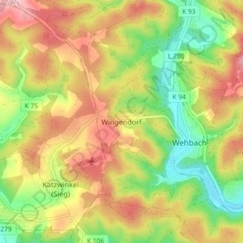
Name: Wingendorf topographic map, elevation, terrain.
Average elevation: 285 m
Minimum elevation: 193 m
Maximum elevation: 379 m
Thank you for supporting this site ❤️
Make a donation
Make a donation
Other topographic maps
Click on a map to view its topography, its elevation and its terrain.
Friedewald
Germany > Rhineland-Palatinate > Landkreis Altenkirchen (Westerwald)
Average elevation: 484 m
Betzdorf
Germany > Rhineland-Palatinate > Landkreis Altenkirchen (Westerwald)
Average elevation: 277 m
Horhausen (Westerwald)
Germany > Rhineland-Palatinate > Landkreis Altenkirchen (Westerwald)
Average elevation: 310 m
Thank you for supporting this site ❤️
Make a donation
Make a donation
Reiferscheid
Germany > Rhineland-Palatinate > Landkreis Altenkirchen (Westerwald)
Average elevation: 240 m