
Thank you for supporting this site ❤️
Make a donation
Make a donation
Bezirk Hartberg-Fürstenfeld topographic map
Click on the map to display elevation.
Thank you for supporting this site ❤️
Make a donation
Make a donation
About this map
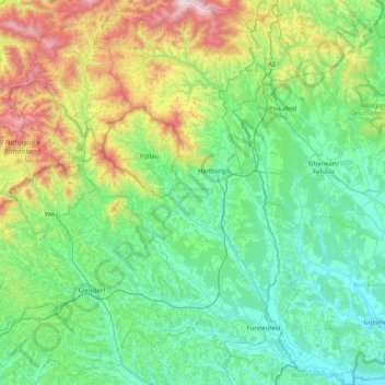
Name: Bezirk Hartberg-Fürstenfeld topographic map, elevation, terrain.
Location: Bezirk Hartberg-Fürstenfeld, Styria, Austria (46.96532 15.71036 47.53042 16.17178)
Average elevation: 541 m
Minimum elevation: 210 m
Maximum elevation: 1,727 m
Thank you for supporting this site ❤️
Make a donation
Make a donation
Other topographic maps
Click on a map to view its topography, its elevation and its terrain.