
Thank you for supporting this site ❤️
Make a donation
Make a donation
Río Negro Province topographic map
Click on the map to display elevation.
Thank you for supporting this site ❤️
Make a donation
Make a donation
Río Negro Province
The climate of the province is temperate at low elevations, and very cold in the higher Andean peaks.
Thank you for supporting this site ❤️
Make a donation
Make a donation
About this map
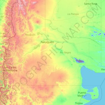
Name: Río Negro Province topographic map, elevation, terrain.
Location: Río Negro Province, Argentina (-41.99209 -71.91207 -37.57478 -62.78956)
Average elevation: 621 m
Minimum elevation: -71 m
Maximum elevation: 4,505 m
Thank you for supporting this site ❤️
Make a donation
Make a donation
Other topographic maps
Click on a map to view its topography, its elevation and its terrain.
Thank you for supporting this site ❤️
Make a donation
Make a donation
Thank you for supporting this site ❤️
Make a donation
Make a donation