
Thank you for supporting this site ❤️
Make a donation
Make a donation
Illizi topographic map
Click on the map to display elevation.
Thank you for supporting this site ❤️
Make a donation
Make a donation
About this map
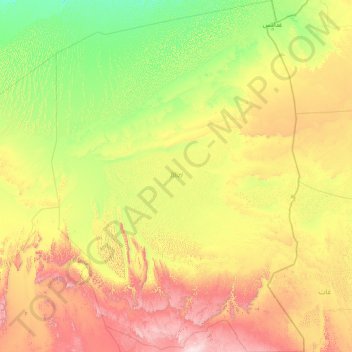
Name: Illizi topographic map, elevation, terrain.
Location: Illizi, Algeria (25.14706 5.63844 30.55904 10.03577)
Average elevation: 561 m
Minimum elevation: 185 m
Maximum elevation: 2,016 m
Thank you for supporting this site ❤️
Make a donation
Make a donation
Other topographic maps
Click on a map to view its topography, its elevation and its terrain.